After a rigorous international search and a unanimous vote of confidence from the Board of Trustees, the Tampa Bay History Center has named Audrey Chapuis as its next President and...
Read MoreYou are using an outdated browser. Please upgrade your browser to improve your experience.
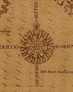
Mapping the American Sea
America’s history has been largely written as an inevitable march from the Atlantic Ocean to the Pacific Ocean, an unstoppable manifest destiny starting with the English colonies of Jamestown and Plymouth, and ending with the California Gold Rush and the completion of the Transcontinental Railroad. This narrative downplays – or outright ignores – the role that the Gulf of Mexico and the states (and countries) bordering it have played throughout the last 500 years. Mapping the American Sea seeks to reset that narrative and place the Gulf States, particularly Florida, along with Mexico and Cuba, in their proper context as crucial players in the history and development of the United States and North America.
The Hernán Cortés letter with accompanying map was purchased through the generosity of Tom Touchton, Nancy and Bob Bolt, and Nell Ward.

BLOG
A new exhibit features rare map–the first to show Florida
(TAMPA, July 26, 2024) – A handful of Florida maps have reached an international level of importance, and this is one of them. Following his conquest of the Aztec Empire in …
View the Touchton Map Library Online
The Touchton Map Library and Florida Center for Cartographic Education is home to thousands of maps, charts, and other documents dating back from the early European exploration of North America more than 500 years ago up through the early 21st century.