
The 1921 Tampa Bay hurricane: then and now
For Tampa residents, a hurricane begins affecting daily life before its wind reaches the bay. In 1921, warnings arrived through telegraph lines and the morning newspaper. Today, forecasts appear on phones, school calendars and household shopping lists.
By the time a hurricane enters the Gulf today, Tampa residents can follow its name, central pressure, forecast track and projected arrival of tropical-storm-force winds through successive advisories. Hillsborough County residents can enter an address into an official map to locate their evacuation zone, while county alerts deliver evacuation orders, flood warnings and road closures directly to their phones.

For Tampa resident Michael Holt, hurricane prep started with a quick Publix run. When Hurricane Dorian approached Florida in 2019, WUSF photographed him leaving the Publix near the University of South Florida with a cart full of supplies. Bottled water had already become scarce, and the shelves that normally held it were empty.
But in 1921, Tampa’s forecast developed one observation at a time.
Every point placed on Tampa’s forecast chart began with a person. Marine observers aboard ships recorded their locations and the weather conditions around them. Weather Bureau employees at coastal stations measured pressure, wind, rainfall and tides.
Every report fixed the storm at one place and one moment. Before it could shape Tampa’s forecast, someone had to take the observation, send it from a ship or coastal station and place it into the hands of a forecaster. The completed warning then had to travel outward through telephone and telegraph lines before newspapers could carry it into Tampa homes.
At noon Oct. 24, the Weather Bureau ordered hurricane warnings along Florida’s west coast from Key West to Apalachicola.
In the path of the storm
Walter J. Bennett, head of Tampa’s U.S. Weather Bureau office, gave residents his assessment in the morning edition of The Tampa Tribune on Oct. 25: “We are apparently in path of the storm.”
The hurricane had crossed the Yucatán Channel and turned northeast through the Gulf toward Florida’s west coast. Bennett and other Weather Bureau forecasters were working from widely separated observations taken aboard ships and at stations on land. Those reports placed the hurricane near Tampa, but they could not tell residents which streets the water would reach.
By noon, Tampa’s telephone and telegraph lines were beginning to fail. Residents went directly to the Weather Bureau office for news as Bennett and his staff recorded the falling pressure, strengthening wind and rising tide. Outside, water crossed Bayshore Boulevard, entered homes and businesses from Hyde Park to downtown and reached the edges of Ybor City.
At 2 p.m. the bay crossed Bayshore
The hurricane made landfall near Tarpon Springs on Oct. 25, 1921. Modern reanalysis classifies it as a Category 3 hurricane at landfall, with winds estimated at approximately 120 mph. Tampa recorded maximum winds of 75 mph and 8.53 inches of rain.
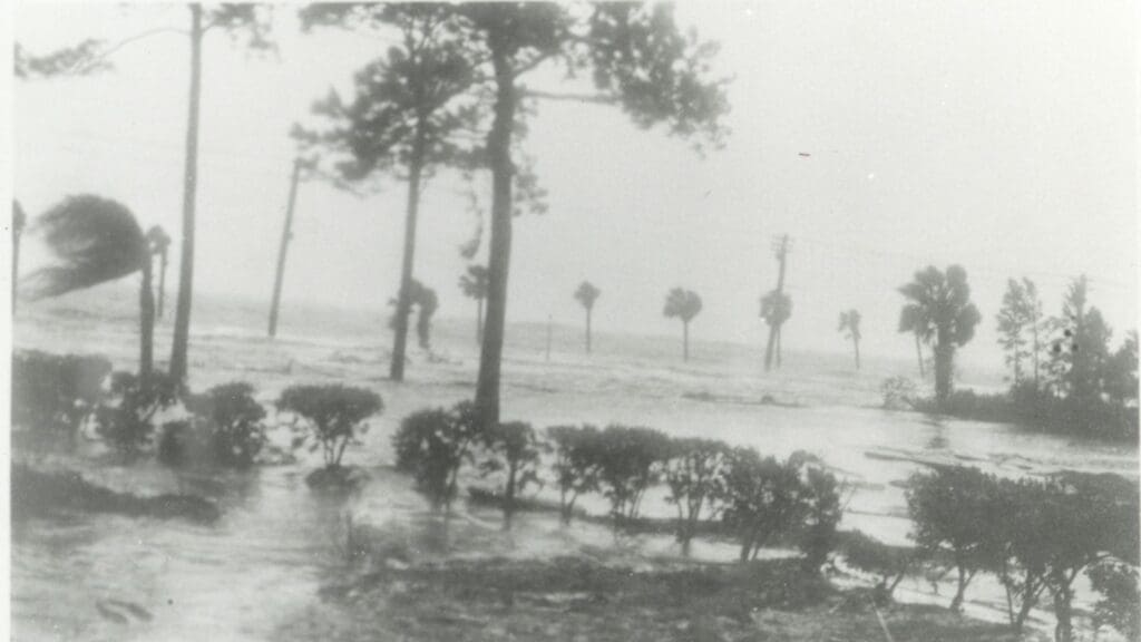
For Tampa residents living near the bay, the hurricane became a flood. At approximately 2 p.m., the tide in Tampa Bay reached an estimated 10.5 feet above mean low water. The surge crossed the Bayshore seawall, covered the boulevard and pulled sections of streetcar track from the roadbed.
At 2:45 p.m., the barometer at Tampa’s Weather Bureau office reached 28.81 inches, its lowest recorded pressure during the storm. Rain continued until approximately 9:15 that evening. Weather Bureau officials believed the recorded 8.53 inches understated the total because wind had blown water from the rain gauge.
Near Ballast Point, a streetcar remained upright while the route beneath it came apart. Rails curved across piles of brick, broken pavement and displaced timber. Men gathered beyond the car to examine what the surge had done.
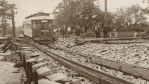 Streetcar damaged by the hurricane near Ballast Point, Oct. 25, 1921. Burgert Brothers, no. 6689. Tampa Bay History Center Collection, 1995.026.026. Burgert Brothers Photographic Collection.
The streetcar served a route Tampa residents used to travel along Bayshore toward Ballast Point. On Oct. 25, the surge undermined long sections of that line and left the car surrounded by broken track and roadway.
Tampa appeared in print as a “City of Ruins”
Newspaper reports, photographs and Weather Bureau measurements documented what Tampa residents encountered after the storm. The Tampa Daily Times described Tampa as a “City of Ruins.” A May 27, 1995, article in The Free Press looked back at the hurricane and quoted another newspaper account: “Bayshore was swept clean.”
Modern Tampa residents build their lives around the bay’s warm water, tropical weather and waterfront neighborhoods. The 1921 hurricane remains part of our collective history because it reveals how quickly that same coastal environment can reshape daily life.
From Newspaper updates to the forecast on your phone
The tools available to Tampa forecasters expanded over the decades that followed. Radar over the following decades, Tampa forecasters began using radar to examine precipitation and storm structure. Aircraft crews carried instruments directly into tropical cyclones, while meteorologists used mathematical models to interpret large collections of atmospheric measurements.
On April 1, 1960, NASA launched TIROS-1, the nation’s first weather satellite. It operated for 78 days and demonstrated that organized weather systems could be monitored from space. TIROS-1 began the satellite era that would eventually change how Tampa residents followed approaching storms.
Today, that information reaches residents soon after publication. A teenager can check the National Hurricane Center’s latest track on a phone between classes. Parents can see when tropical-storm-force winds may begin, then work backward from that hour: bring in patio furniture, charge phones, find the flashlights and finish shopping before conditions deteriorate. Families can keep water, shelf-stable food and batteries on hand throughout hurricane season, leaving fewer decisions for the final days before a storm.
Parents receive updates as Hillsborough County Public Schools and county emergency officials decide when campuses, athletic programs and after-school activities will close.
County information becomes equally personal. Residents can enter a home address into Hillsborough County’s evacuation map and learn whether that property lies in Zone A, B, C, D or E. HCFL Alert can send location-specific evacuation notices, flood warnings and road closures by text, email or phone call. For a family in a low-lying neighborhood, those tools connect a regional forecast to the home, roads and people they need to protect.
In 1921, hurricane warnings reached Tampa residents through telegraph lines, Weather Bureau staff and newspapers. Today, maps, projected arrival times, school announcements and evacuation instructions help families decide what to do before the weather reaches their neighborhood.
The Tampa Bay History Center preserves photographs, newspapers, and other materials that connect the 1921 hurricane to the streets, neighborhoods, and waterways where it happened. Visit the History Center to explore more of Tampa Bay’s past and support the continued care of the collections that hold the region’s history.
Curious about Florida life in the 1920s? Watch the History Center’s Florida Conversations program, Florida in the 1920s.

About the Author
Sara Cheesewright serves as Digital Marketing Associate at the Tampa Bay History Center. She holds a Master of Arts from St. John’s University and brings more than five years of editorial expertise to her work. As a lifelong storyteller, she is deeply...